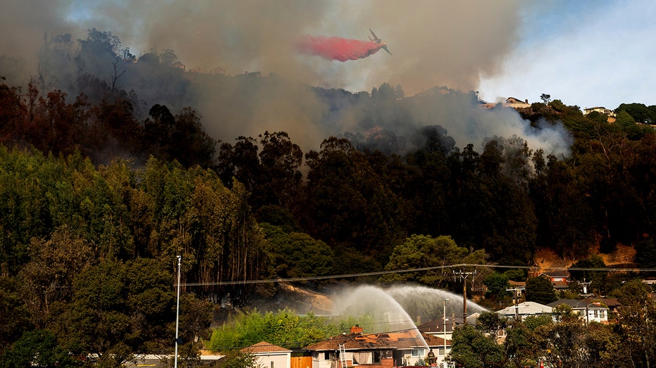
At least seven homes were burned by a fast-moving fire in a hillside neighborhood of Oakland, California; hundreds of people were ordered to evacuate.
A fast-moving fire burned at least seven homes Friday as it raced along a hillside neighborhood in the city of Oakland where hundreds of people were ordered to be evacuated, a fire official said.
Friday’s fire comes as forecasters issued red flag warnings for fire danger until Saturday across a large swath of the state. It was not immediately clear what caused the Oakland blaze.
RECORD FIRE IN CALIFORNIA BURNS HUNDREDS OF ACRES, FORCES EVACUATIONS, INJURES MULTIPLE FIREFIGHTERS
Oakland Fire Department spokesperson Michael Hunt said he did not have an exact figure of the evacuees but estimated that hundreds of residents had been told to leave the area.
No injuries were immediately reported.
Crews were called to the area around 1:30 p.m. for a vegetation fire. The blaze grew to 13 acres (5.26 hectares) within three hours before crews were able to stop it from advancing, the Oakland Fire Department said.
The fire was near the 580 Freeway, which connects the San Francisco Bay Area to central California, causing traffic jams as people tried to leave the area and smoke wafted over the city of 440,000.
Several aircraft with the California Department of Forestry and Fire Protection dropped fire retardant and state highway officials briefly shut down lanes on westbound 580 as authorities asked people to avoid the area, California Highway Patrol Sgt. Andrew Barclay said.
Smoke was visible 2 to 3 miles (3 to 5 kilometers) away. Firetrucks and ambulances struggled to get through the gridlock in the freeway’s westbound lanes, their sirens blasting to get vehicles to move out of their way as they raced toward the blaze. The traffic frustrated some drivers enough that they exited the roadway through on-ramps, while others drove on the freeway’s shoulder. The side streets remained heavily gridlocked as well.
The fire burned in the Oakland hills where a 1991 fire destroyed nearly 3,000 homes and killed 25 people.
Red flag warnings for fire danger until Saturday are in place from the central coast through the San Francisco Bay Area and into northern Shasta County, not far from the Oregon border.
The red flag warnings were also issued in parts of Southern California where another brush fire was burning toward homes in the Rolling Heights area of Los Angeles County, the Los Angeles County Fire Department said.
The fire was reported around 3:00 p.m. in the Hacienda Heights hills where firefighters on the ground and in the air were trying to stop the 5-acre (2-hectare) blaze from reaching nearby homes, the department said. No evacuations have been ordered.
A California utility shut off power in 19 counties in the northern and central part of the state as a major ” diablo wind ” — notorious in autumn for its hot, dry gusts — spiked the risk of power lines sparking a wildfire.
About 16,000 customers were without electricity Friday after Pacific Gas and Electric shut off power.
The fire began as a vegetation fire near the freeway and grew uphill, Oakland Fire Department spokesperson Michael Hunt told The Associated Press.
A nearby elementary school was set up to serve as a temporary shelter.
During a diablo wind, common in the fall, the air is so dry that relative humidity levels plunge, drying out vegetation and making it ready to burn. The name — “diablo” is Spanish for “devil” — is informally applied to a hot wind that blows near the San Francisco region from the interior toward the coast as high pressure builds over the West.
The “diablo wind” is forecast to cause sustained winds reaching 35 mph (56 kph) in many areas, with possible gusts topping 65 mph (104 kph) along mountaintops, according to the National Weather Service. The strong winds are expected to last through part of the weekend.
A total of about 20,000 customers could lose power temporarily in the next couple of days, PG&E said in a statement Friday.
The National Weather Service issued red flag warnings for the valleys and mountains of Los Angeles County, portions of the Inland Empire, and the San Bernardino Mountains from Santa Anas, dry, warm and gusty northeast winds that blow from the interior of Southern California toward the coast and offshore The winds move in the opposite direction of the normal onshore flow that carries moist air from the Pacific into the region.
Winds around greater Los Angeles won’t be as powerful as up north, with gusts between 25 and 40 mph (40 and 64 kph) possible in mountains and foothills, said Mike Wofford, a meteorologist with the weather service’s Los Angeles-area office.
The strongest winds were being recorded in the Santa Monica and San Gabriel mountains, where Friday there were gusts between 45 and 55 mph (72 and 88 kph) with isolated gusts up to 60 mph (96 kph), he said.
Meanwhile, some mountaintops around Lake Tahoe received light snowfall overnight Friday, according to the National Weather Service in Reno, Nevada. Near sub-freezing temperatures are expected again Friday night into Saturday.
Wind sensors in two peaks west of Lake Tahoe registered 75 and 104 mph (120 kph and 167 kph) winds Friday with strong winds expected to continue through the night before tapering off Saturday morning, the National Weather Service said.
The service also issued its first freeze warning of the season along the Sierra’s eastern front effective from 2 a.m. to 9 a.m. Friday from south of Carson City to the north through Reno into Lassen, Sierra and Plumas counties in California where temperatures could dip into the low 20s Fahrenheit (-5 Celsius).


